Friday, 6 October 2023

British Pathe: "Bombed Factory - Croydon (1940)"

 The British Pathe website of black and white films contains one called “Bombed Factory – Croydon 1941?”, which you can view by clicking here.

It takes two minutes and three seconds to view but in that time the camera crew take up 14 different positions, typically only shooting about six seconds of film in each one so it is a little disorientating on first viewing.  You can slow down the film to one-quarter of the speed by clicking on the three vertical dots in the bottom right of the film and selecting playback speed.  But what are you witnessing?

It’s Thursday 15th August 1940, probably about 8pm in the evening of what had been a sunny day.  What we know call the Second World War was less than a year old but in that time Germany had over-run first Poland, then Denmark and Norway, then the Netherlands and Belgium and finally – unimaginably – France.  The British army had been evacuated from Dunkirk but without the tanks and artillery essential to compete with the German army.  The fight for control of the air space over southern Britain, the potential invasion landing grounds, was now beginning.

We’re a few hundred yards from the perimeter of RAF Croydon, the transformed main civilian airport in London.  Starting at 6.50pm and ending about 10 minutes later, the RAF station had been dive-bombed by up to 20 Messerschmitt 110s.  Intentionally or otherwise, factories nearby were bombed as well, and this is what the film shows.

The film starts just off of Stafford Road.  After panning rapidly in the first two seconds, the camera settles with a view south along Princes Way (Camera Position 1).  The set of four steps is notable in the foreground and these can be matched to the following street view (from 2012 as it is the clearest view, but still there today):


Note two-thirds of the steps have been covered with a ramp to allow vehicles access.  This building survives from the National Aircraft Factory, the first building on the site in 1917 and the steps led up to the platform for a railway line which would have run north along Kingsway and across Stafford Road to join the existing line.

The fire engine in the Pathe film would have been parked roughly where the van is in the 2012 view.

The building on the left of Princes Way in 1940 makes a contrast to the back of the Amazon depot we see today – this was the Hatcham Rubber Company.

After 8 seconds, the camera moves to the other side of Princes Way (Camera Position 2), approximately level with Camera Position 1 and facing south.  On the left of the frame, we can see the sign “Goods Entrance” by the doorway to Hatcham’s.


After 15 seconds we move along Princes Way, towards the smoke we have been looking at in the distance.  This is impossible to recreate exactly from Google Streetview because the camera was close to the buildings on the right of the street and the only pictures are from the left side.


The modern reveals that just around the corner to the right, out of camera shot in the 1940 film was the distinctive front of Bourjois House, the makers of soap and perfume, and very little changed to this day.

The building to the immediate right of the camera in 1940 was a store for the Central Electricity Generating Board.  Ahead and to the left is a parked car and just to the right what appears to be a public shelter for air raids, designed as a small, temporary shelter for those caught out in the open.  Behind that we see smoke and rubble, and in the distance a much taller structure looms; this is the back of C Hangar which fronted on to the airfield itself.  The end we can see housed Rollason’s Aircraft Services and the hanger stretched off to the left to Purley Way; that end housed Redwing Aircraft.

Noted the injured woman with two supporters moving from right to left (17 to 20 seconds into the film) probably someone injured at Bourjois.

After 24 seconds the camera advances about ten yards further forwards (Camera Position 4, approximated below taken from 2017).


We can now clearly see that on the opposite side of the street, a substantial building has been wrecked; this is the factory of the British NSF Company, makers of electrical components.  At 28 seconds the camera starts to pan left and at 29 seconds we see the street sign for Queens Way and behind that the extent of the destruction with the first intact parts of the factory not visible until the film reaches 32 seconds.

At 35 seconds the camera moves to the left of the previous one, crossing Princes Way and into Queens Way.


Notably the triangular roofs on the left side of the 1940 film still survive; these were part of the 1917 National Aircraft Factory.

The camera then crosses Queensway and seems to be standing among damaged cars on the street, roughly where the cars are parked in the modern view above.  The camera focuses on a damaged car, then pans left to show three men in a group, which then breaks up and we see the shock on the face of one young man (RAF?).  As the camera continues to pan to the left we see the rest of the undamaged factory running the length of Queens Way to purely Way.  In 1940 this would have been occupied by Bowater’s who had corrugated cardboard and cardboard boxes; they are responsible for Merlin House, the art deco style offices facing onto Purley Way. 


The two chimneys confused me initially as I thought they were the power station (at modern day IKEA) which would mean this photo was facing north.  However, a 19139 aerial view shows two chimneys on the roof of Bowaters and we can also align with the white houses in the distance on Purley Way – the distinctive sloping roof just visible in 1940 has been lost due to an extension in the last few years, but using Google Streetview’s 2012 image the original can be seen:


Back in 1940, the camera then takes up three positions within the wrecked NSF factory.  At 69 seconds the camera returns outside to show firemen setting up a hose but there is no clue to the exact location.

At 86 seconds the camera moves again and shows a man pushing his bike over a maze of water hoses for fire-fighting.  This seems to be back in Princes Way at the side of Bourjois, looking north and hence back towards the position where the film started:


The camera then goes back into the wreckage of the British NSF factory, coming back to the road for the final sequence, starting at 112 seconds.  We seem to be in Princes Way at the side of Bourjois but looking south towards the RAF airfield.


Tuesday, 19 September 2023

Denholme Road, Paddington - 8th September 1940


Denholme Road is a tree-lined street of predominantly three-storey houses in West Kilburn, formerly in the London borough of Paddington).


In the map above, Denholme Road is flagged in red in the top left corner, with central London in the bottom right corner.

On the evening of Sunday 8th September 1940, Elizabeth Bernard had walked the ten minutes from her home at 83 Walterton Road to number 23 Denholme Road to meet her friend, Mary Hart. 

They would have had a lot to discuss – the docklands area in the east end had been the target for the first mass daylight bombing attack on London the previous day and repeat bombings during the night had kept the fires burning.  Aged 77 and 69 respectively, both were children of the Victorian age, and they must have looked back to the days of peace and British supremacy when an attack on London would have been unthinkable.  Elizabeth had spent a lot of her adult life in the east end so would know the areas bombed.  They might even have known about a local man, Alfred Woolgar, who had been killed when RAF Croydon was bombed a few weeks before; he had lived at home with his parents at 52 Fordingley Road (Elizabeth passed the street on her way there).

Mary rented a room from the Wallises, James (a retired policeman) and Amelia, aged 59 and 52.  They had lived there for about thirty years since they were married, interrupted only by James’s service in the 1914 to 1918 War when he joined the military police and was posted to Egypt.

They might have noticed a neighbour, 19-year old Constance Brown returning home from a lecture on air-raid precautions; she lived with her parents at number 25, on the corner of Macroom Road.  (In the photo at the start of this post, numbers 23 and 25 would have been on the right hand side, where the very obviously newer block of flats stand.)

At 9.50, Elizabeth and Mary were in the hallway of number 23, maybe as Elizabeth was leaving.  The Wallises were sitting at a table.  Upstairs, the Clarkes, Wilfred and Dorothy, had got their baby son to sleep.  In Constance Brown’s words, “About 9pm there was a noise like a train rattling down, then a shrill whistle and a bang, then we went up in the air and down again.” 

This map shows the damage recorded to houses, the darker colour denoting more damage and black showing complete destruction:


The damage to the houses in Macroom Road suggests the bomb exploded at the rear of numbers 23 and 25 Denholme Road.

The Wallises were killed where they sat.  Upstairs, Mrs Clarke heard the sound of the bomb falling and threw herself across the cot but in vain: both her legs were broken by falling rubble and baby Derek died.  Also at number 23, 15-year old Moira Smith died in her bed; she had been evacuated to Exeter at the outbreak of the war and had just returned home to her parents, Harold and Rosetta.

In the hallway of number 23, Elizabeth Bernard and Mary Hart were covered in dust and some rubble.  Mary was helped out by two men, probably neighbours, but Elizabeth was part-buried and not seen.

Just round the corner at 119 Fernhead Road an off-duty policeman, Richmond Rickards (a 35-year old Welshman), heard the explosion and ran to the scene.  He may have known Constance’s father, Clarence Brown, or James Wallis, both in the police reserves.  On arriving, he heard groans and cleared enough rubble to get into the front passage and found Elizabeth, injured but conscious.  As he carried her out, another bomb fell nearby causing the parts of the building that were still standing to collapse.  He carried Elizabeth to shelter, then returned to help again.

In the wreckage next door, Constance Brown remembered, “I did not lose consciousness and was covered by rubble and pinned down by a dining chair, which had lost its seat and was over my shoulders.”  She seems to have been in a pocket within the rubble.  “The gentleman from the ground floor was injured beside me, but we couldn’t move to help each other.”  (Based on the 1939 register this would probably be Ernest Johns, 24, a delivery van driver.)

It was probably four to five hours later (Constance said “after what seemed ages”): “I can remember the sounds of men digging and then calling to us.  When the rescue gang got nearer, they told us to cover our heads.  I put my arms up, and a brick smashed into my elbow, and my face and hair were covered in glass ...  Then the rescuers said they were going to lower flasks of water on a rope.  I managed to catch one but could not get my head back to drink because the back of the dining chair made putting my head back impossible.  Eventually I was released, and to add insult to injury the man assisting me said, “You’ll be alright now, son.”  Not very flattering for a 19-year-old girl.”

It was 5.30 the next morning when she was rescued.  Four people were killed, 19 injured.  For Constance the sadness was not quite yet over: “We lost our home and all our belongings.  The hundredweight of coal we’d got in for the winter was looted, along with some unbroken moveable objects and clothing.”

Constance subsequently married (becoming Constance Blunsum) and died in Chelmsford in 2015.  Strangely her account does not mention her parents, other than her father’s occupation.

Richmond Rickards was awarded the British Empire Medal for bravery; there is a photo of him with his medal, but I am waiting permission to post it.  Strangely, the paperwork for his medal names him as Richard Rickards and gives his age as 26 rather than the correct figure of 36, but then states the correct home address and length of service in the police (15 years, which would not have been possible if he was 26).  He moved back to Wales in later life with his wife Edith and died in 1981.

Elizabeth Barnard was made of strong stuff.  She had survived the east end of London where three of her four children had died by the time she was 27 years old.  In her working life she had been a ‘month nurse’, the nurse who helped a mother with the new-born while they were ‘confined’ for the first month before she was widowed.  After being buried in rubble and rescued by PC Rickards she lived another eleven years, dying at the age of 88.

Monday, 4 September 2023

East Acton, 1st October 1940


In early 1939 as hopes faded that Hitler’s ambitions for territorial expansion could be appeased, local councils throughout the UK rushed to make preparations for shelters from air raids.  There was a strong belief that enemy aircraft could not be stopped (the bomber will always get through), that bombing attacks could kill tens of thousands each day, and that attacks would probably begin on the day war was declared. 

One of the solutions was to dig trenches in parks and other green urban areas, line them with wooden supports, and put a concrete slab on top.  Rather than being one big room, these would have had different arms or bays, the shape of a passage-way with benches on either side for sitting and electric lights; there was probably a simple toilet.  They were designed on the assumption raids would last a few hours, not all night and there was no ventilation or heating, so they tended to become cold, damp and smelly.  However, they could provide a shelter for hundreds of local people and no doubt drew on the experience of older local men digging trenches in France and Belgium just over twenty years earlier at a time when skilled builders were in short supply.

These photos show a trench shelter under construction in Hyde Park and the inside of a trench shelter.


One such trench system was dug on The Common in Action, just off Old Oak Common Lane.  (It is referred to in official documents as The Trenches, The Fairway).  People would have gone here when alerted by the air raid siren or may even have slept here overnight even when there was no siren by the evening.

As the night of Monday 30th September 1940 passed into Tuesday morning, over 200 people were in the shelter.  The shelter staff were all ARP members.  Ben Hawes was in charge, a guard on London Underground trains from Old Oak Common Lane.  Assisting him were two trench marshals, sisters Gwendoline and Marjorie Jones from 10 Long Drive, also a few minutes’ walk away.


In this 2023 view The Common is at the bottom of the photo.  Long Drive runs horizontally at the top of the photo.  Taylor's Close is the oval shaped road in the top-left corner.  Old Oak Common lane runs vertically down the right hand side of the photo.

This sketch is from the BBC website and shows the same area in wartime (to interpret the numbers see this webpage https://www.bbc.co.uk/history/ww2peopleswar/stories/31/a8880131.shtml)

Approaching from the Thames Estuary, about 175 German bombers flew over London that might.  While they would have had targets, bomb-aiming was primitive and the Thames was probably the main navigation guide.  The target for those over Acton may have been the railway depot at old Oak Common (now home to Elizabeth Line trains).

At 05.22 a bomb dropped and exploded on or closer to the right-hand side of the trench shelters.  Gwen Clarke, aged 27 and a warehouse assistant, described what happened:

“We did not hear any sound.  I was about half way in the bay that was struck, when the lights went out and two girls on the left side and a boy on the right side were thrown across; also the end of the bay seemed to come towards us. 

I used my torch and found some people struggling among the collapsed wall.  Telling the people in the shelter to stay where they were my sister and I picked up three people near us and laid them on the benches. 

While my sister rendered first aid, I released two girls, a woman and two boys who were partly trapped, although I could hardly see for dust.  We got them near the entrance for fear of further collapse of the walls.  I went back to where the people were trapped, but could do nothing but assure that help was on the way.  I then helped my sister with the injured. 

By this time some of the Services were arriving, so we handed our patients over to them.”

As rescue work continued, the Clark sisters made tea.  The case was reported by the District warden and the Clark sisters received commendations from the government for their work.

Gwendoline Clark was four years younger than her sister and did not marry, dying in 1957.  In Gwen’s account, Marjorie is the one tending the wounded and in the 1939 Register she seems to be recorded as a nurse at the North Middlesex Hospital in Edmonton.  The doubt is because the name is originally given as Marjorie B Jones but the surname has been amended to Clark.  At the time of the bombing she was living at 10 Long Drive with her parents and her occupation is described as domestic help (maybe her parents were inform?)  She had been a part-time warden for five months.  There is no trace of her in records after 1940.

Ben Hawes, the shelter marshal, was 46 at the time living at 155 Old Oak Common Lane with his wife Rose.  Six weeks after the bombing, on 12th November, he was at his job as a guard for London Underground at Sloane Square Station when he was killed in a devastating bomb explosion with around 40 other people.

The people who died at The Common were in two family groups. 

Mary Maud Hersey had celebrated her 52nd birthday three days ago.  She was in the trench shelter with at least three of her children, Ivy (aged 29), Cyril (19) and Olive (13).  We don’t know for certain that her husband, William Mike Hersey, or her other sons, William Henry (28) and Ronald (20), were there as well but as they were all listed in the 1939 Register at 162 Old Oak Common Lane it seems likely.

Alice Cooper was four past her 59th Birthday, born in Stepney and living in Poplar.  At the time of the 1939 Register she was living in Swindon, and a family tree on ancestry.co.uk suggests this was because she had been evacuated with her daughter, 20-year old Alice Gertrude Cooper.  They lived with a widow, Mary Wrangham at 23 Bibury Road.  (In the 1939 Register two records at the same address are closed, were these also evacuees?)  Alice’s husband and two adult sons were recorded as living at 129 Campbell Road in Poplar (in modern terms by Devons Road DLR Station).  In the east end of London this would have been near the docks, a likely target for German bombing, so the evacuation made sense; the men stayed presumably because they were all in paid employment and could not afford to give that up.


Campbell Road around 50 years ago. 129, home of the Coopers on the right near the trees (only the railway bridge and possibly one of the trees survives today).

So, what were Alice and her daughter doing in Acton just over a year later?  It was common for people evacuated to want to return, but their address is given as 24 Taylors Close, just off Long Drive and a few minutes’ walk from The Common.  Why did they not move back to Campbell Road?  Possibly it was regarded as too dangerous – several residents of their street had been killed when a street shelter was bombed in Sutherland Road just over two weeks before, on the opening day of the daylight Blitz on London.  But were the whole family in Acton, with the men commuting back to their work (surely they could not afford two houses?) - were they also in the trench shelter but survived?  We have one clue.  Alice’s son, Albert Henry, died around a month later at Hammersmith Hospital (less than a mile away from The Common); while he is not recorded in the Commonwealth War Graves Commission register of civilian war dead, it is possible he was missed.

Friday, 1 September 2023

An ambulance in a bombed street: Ladywell Park, Lewisham


I chanced upon this photo, taken in the Ladywell area of Lewisham on 18 September 1940.  In common with most wartime photographs, other recorded details were excluded in case they helped the enemy.  But where was it?

The Commonwealth War Graves Commission (CWGC) holds the national register of civilians killed in the Second World War in the UK, at sea and overseas, including where they died.  From this I could see that on the 17th September there were several incidents in Lewisham but the one that seemed the best match was in a street called Ladywell Park.

No street of that name now exists, but the 1940 edition of Bartholemews Reference Atlas of Greater London revealed it was a road off of Lewisham High Street (to the east) opposite to the junction with Ladywell Road.  (Later this was the sight of Ladywell Leisure centre, now demolished.)


In the background of the photo, at right angles to Ladywell Park, a building is visible with a distinctive pediment at the roofline.  Looking at Google Maps street view, it can be matched to the building still standing at 324 to 328 Lewisham High Street.


This is the sight of the junction with Ladywell Park as it looks today:


From the book “Red Alert” by Lewis Blake, a history of the blitz in south-east London, a parachute mine exploded at 11.30pm on Tuesday 17th September.  This was a naval mine, about 6 feet long, dropped from a bomber at about 40 mph after the parachute opened.  After touching the ground, it had a timer to explode after 25 seconds and had been used for the first time in the UK on the previous night.  (For more information see https://www.iwm.org.uk/collections/item/object/30020471).  This is a painting of a mine falling in another incident:


This extract from the London County Council sows the damage done to Ladywell Park, black denoting complete destruction:


Blake says 25 people died in this incident although CWGC only lists 24 names.  These include

·         John Smart, a labourer, and four of his children at number 18

·         Richard Butler, a timberman, his wife, adult daughter, daughter-in-law and two grandchildren at number 16.  At the same address, George Johnson, a lorry driver, and two of his children.

·         At number 7, newly married Charles Lawrence, a compositor (typesetter) and his wife Kathleen.

·         At number 1, Mary White and her adult daughter Annie, who usually lived in Kentish Town with her father but was evidently visiting her mother at the time.

A common idea is that in the Blitz, Londoners slept in stations on the Underground but of course this depended on there being a station near you and that y could get a place.  Many people either chanced it at home, used a shelter in their garden, or used a public shelter in the street.  However, less than a week before at least 36 people had been killed in a public street shelter less than a mile from Ladywell Park, at Albion Way.  This might have deterred people from going to a similar shelter overnight.

The death toll could have been higher.  One of the rescuers, John Donno, a labourer, retrieved four people alive by crawling into the rubble of the houses.  He went back for a fifth person but a rubble fall knocked him out and he had to be rescued himself, awaking in hospital.  For this, he was awarded the George Medal, the highest award for civilian bravery.  Very little is known about John Donno.  Born on 18th October 1884, he lived at 56 Laleham Road at the time, with his wife, Frances. Looking at the original photo again, we can perhaps imagine him crawling into the wreckage in the middle of the night


Here are two views of Ladywell Park, the first probably looking towards Lewisham High Street and the other looking towards Campshill Road:


The following aerial view shows the Lewisham URC Church on the corner of Courthill Road and Lewisham High Street in the bottom left, Lewisham High Street runs from left to right across the photo in the foreground.  Ladywell Park is the tree lined street running away from the camera on the right hand side and curving towards the centre of the photo:


This is an approximation to the same view today:


Finally, here is a close-up of the houses closest to the High Street:


Saturday, 16 January 2016

Parker Street, 15th November 1940 - a bomb beside London City Airport DLR Station

On 15th November Coventry smoldered from the intense attack the night before but the attack was not renewed.  The Luftwaffe returned to London with the docks high on the list of targets.
I have not been able to find an account of what happened in Silvertown that night but this photo shows the aftermath:

Seemingly taken several years later (one source says 1944) it shows Parker Street, looking north to the Royal Victoria Dock.  The gap on the right hand side seems to be the site of cleared buildings that had been bombed.
Today, we might be more familiar with the view looking back towards the wartime cameraman from the docks, which now form London City Airport:

Planes are visible at the bottom of the photo, with the DLR railway station in the centre; just above that and to the right is the silver-coloured school building, and Parker Road runs to the right of the school and playground as we look at it.  The proximity in wartime to factories at the top of the photo, as well as the dock (now airport) are obvious.  This photo was taken by a Luftwaffe reconnaissance flight on 29th October, seventeen days before the bombing:

Factories and the dock facility are marked as targets.

The CWGC register of civilian war dead shows two people died in Parker Road that night and it seems likely a third person was fatally injured:
Annie Louisa Kerr died at 5 Parker Street, aged 35.  She was probably born Hannah Louisa Moles in 1905 in Silvertown and in 1911 she was living with her family in Silvertown where her father, Jim, was a general labourer in a rubber works.  She was known as Louisa and the family of seven lived in a three room house at 49 Andrew Street.  (Andrew Street may have partly disappeared under Silvertown Way but the remnant could be renamed Camel Street.  The area seems to have been popular with people moving from Ireland and one branch of the Moles family is found in that country).
By 1940 her parents lived in Woodford, about 7 miles north.  She was the wife of Walter E Kerr (probably Walter Edward Kerr born 1902).  They had been married 17 years and probably had two children Walter and Mary who would have been 15 and 14 at the time of the bombing.
Walter, her husband subsequently married Violet Moles, presumably a relative of Annie, four years later; and after the war they lived in the same street as Annie’s parents.  Walter died on 25th September 1948.
Elizabeth Maycock aged 75 and a widow died next door to Annie at Number 7.  CWGC only gives her husband’s first initial, J.  The 1901 Census shows John and Elizabeth Maycock living at 37 Ashburton Road, just the other side of the Royal Albert Dock, with their baby Alfred and adopted son Edward Booseby (born 1898).  John was 54, his wife’s age was said to be 36.  Sadly baby Alfred died shortly after the Census.)
They had been married on Christmas Day 1895, John was a widower (and the son of a soldier), while Elizabeth was a spinster aged around 35.  She was born Elizabeth Poolten but when her mother remarried she seems to have used her stepfather’s surname, Morris, for some time.  She may have been born in Mauritius in 1861 although the 1901 Census says she was born in Cape Town, South Africa; the family travelled around, younger siblings having been born in Gibraltar.
The CWGC record shows Elizabeth Larn died at Royal Albert Dock Hospital on the same day and her home address was 9 Parker Street; it seems reasonable to presume she was injured at home and died in hospital.  She was born Elizabeth Benmore on 9th December 1899 in Poplar.   In the 1901 Census the family lived at 5 West Street, Poplar, in the parish of All Saints, and her father’s occupation was general labourer.
The 1911 Census entry is unusual because Elizabeth lived at 1 Oak Road, Canning Town with her mother and 4 siblings; there is no mention of her father but further investigation shows him registered at 5 Oak Road with 7 others!
Her mother died in 1916 and her father (by then a ship’s fireman) died of pleurisy and pneumonia one year later.  On his death certificate Elizabeth was given as the informant and they were living at 41 Anne Street, Plaistow.
She married Thomas R Larn in 1921, and they had eight children: Thomas Charles (1921-1949); Thomas J b 1922; twins Doris and Winifred (1923-1923); Rosina b 1924; Frederick J b 1926; Sidney Alfred (1927-1978); and Irene E (1931-1932).


While I could not find an eye witness account of this particular riad, this is the story of one resident of Parker Street:

Note he refers to a bomb which deafened one of his sisters, and another sister almost falling into a bomb crater; these may have been the 15th November attack.

Monday, 4 January 2016

Clydeside 13th and 14th March 1941: timetable of the attacks

To date I have posted about individual incidents.  In this post, I have used two key books to try to construct a timetable for the air-raids on Clydeside on 13th and 14th March 1941.  I plan to add more detail and also to post on individual incidents

Notes
My referencing system is to use the first letter of my source (J=Jeffrey, for example), then the page number followed by the paragraph on that page e.g. J56.1 refers to Jeffrey’s book, page 56, paragraph 1.  The three source books are as follows:
J = Jeffrey “This Time of Crisis”
M = MacPhail “The Clydebank Blitz”
C = Cromwell “Bankhead: The Story of a Primary School at War”

Plain font indicates what appear to be statements of fact.  Italics show my comments and interpretation.  Bold font shows an event where the CWGC list of civilian war dead indicates people were killed. 

Thursday 13th March 1941
19.30 British military intelligence warning sent to Glasgow/Clydebank based on direction of German air force navigational beam. (M16.2)

20.30 Yellow warning (meaning ‘possible air-raid’) at Bankhead School AFS Watch Room. (C56.4)

20.40 (estimated) Purple warning (meaning ‘probable raid, all CD staff to stand-to’) received at Bankhead (“a few minutes after” the yellow warning at 20.30). (C56.4)

20.55 (estimated) Red warning (meaning ‘sirens to be sounded’) received at Bankhead (“shortly before 9pm”). (C56.4)

21.00 Bombing starts in Liverpool (M17.2).  McPhail suggested this was a diversion but “After the Battle Volume 2” shows the Germans planned to bomb both Clydeside and Merseyside in separate attacks.

21.00 (estimate) sirens in Clydebank (M15.2) based on “9 o’clock news had just started” on radio and teacher had just dismissed evening class at 9pm).  Chief Constable was at John Browns for scheduled test at 21.20 but they went off early. (M34.2)
Planes could be heard at Dalmuir as siren ended “approaching up the river”. (J56.1)

21.05 (estimate) “Almost from the moment the sirens sounded” flares falling in Clydebank (J56.3)
Hugh Campbell kicked incendiary from lean-to where ambulance stored at Singer’s Ground (M18.1, J56.1)
Possibly: fire started at Singer’s timber store (M19.3), possibly also Yoker Distillery

21.10 sirens in Glasgow (J55.6)

21.10 McLintock at Bankhead could hear planes overhead (C56.5)

21.15 (or 21.20) parachute mine at Bankhead School, according to Cromwell using school log, police and fire records, plus McLintock.

21.20 (estimate) bomb on 11 Queen Victoria Drive (J56.5)

21.23 bomb on Beardmore’s Diesel Works (J56.5)

21.25 (estimate) Rescue party and bus ambulance leave Esk Street depot to go to Bankhead School (“in under four minutes”, J57.2)

21.30 first part of main enemy force arrived over Clydebank (M18.2) – assume he is distinguishing between pathfinders dropping incendiaries and main bombing force.

21.30 (estimate) bomb on south side of Second Avenue opposite Albert Road (M18.2 quotes police officer that it was the first) – suggests higher numbers (163, etc) on Second Avenue.  Note that J57.5 implies it was later – but could be referring to a subsequent incident.
M32.2 story of Sergeant John MacLeod of 43 Albert Road on his way to duty when bomb demolished houses on either side of him – rescued people

21.30 (estimate) bomb on 57-59 Whitecrook Road (M18.2 says some people said this was the first bomb)

21.34 first aircraft of Luftflotte 3 over area, 4 He 111 of I/KG27 (nb records of Luftflotte 2 were destroyed, so these were not necessarily the first German aircraft), to 21.50

21.35 (estimate) bomb pub on corner of Beardmore Street and Dumbarton Road, witnessed by Hugh Campbell (J56.5) – timing estimated from time taken to report incident at Beardmore’s at 21.25, and Campbell to set off

21.35 German records say anti-aircraft fire started (M45.2)

21.38 bomb on Sick Children’s Hospital, Garscadden Road (J57.1)

21.40 (estimate) 21.38 incident “followed almost immediately” by bombs in Knightswood and Drumchapel: Trinley Road, Cowdenhill Avenue, Friarscourt Avenue, Baldwin Avenue, Fereneze Crescent, Fulwood Avenue
73 Friarscourt Avenue on fire from bomb in Friars Place
21.45 (estimate) Bombs at Eastcote Avenue, corner of Crow Road and Sackville Street and in Barclay Curle Recreation Ground opposite. 
Chronology unclear – assume Jeffrey 57.1 is in order

21.45 Dalmuir telephone, electricity and water had been cut off by now (J58.6)

21.45 (estimate) William Smillie and crew helped prop up shelter on Second Avenue (J58.4)

21.48 12 JU88 of I/KG54 arrive over target, to 22.55

Jeffrey (57.2) would put Bankhead School about here if in chronological order

21.51 600 Squadron Blenheim (Denby and Guest) spotted He-111 of KGr-100 (J61.3)

21.54 12 He 111 of KGr100 arrive over target, to 22.25

21.55 bomb on Boreland Drive, Knightswood, outside 77-79 (J59.2)

Elgin Street School damaged by blast from a parachute mine, equipment useless, electricity and water cut. Supplies and staff moved to shelters, 190 treated there.  (MacPhail 27.4 cf. J62.4)

Radnor Park School, Kilbowie Road, on fire “occurred early on” (M19.4)

22.00 (estimate) Campbell’s ambulance with Beardmore casualties damaged en route by a further bomb, two injured killed by manhole cover blown through roof of ambulance by blast (J 56.5)

22.00 (estimate) Wounded being put on ambulances at Whitecrook Road when another bomb exploded in Stanford Street, fatally injuring stretcher bearer. (J64.2)
Aitchison Blair factory in Stanford Street bombed early on, could be the same incident (M18.2)

22.00 (estimate) Livingstone Street – timing: must come after Second Avenue from Smillie’s evidence (J58.3 and J58.4) MacPhail implies this was an explosion early on and links it to story of number 69 (M18.2).

22.00 raid began on Hull, lasted until 02.25 (M17.2)

22.05 9 He111 of I/KG27 arrive over target, to 22.32

22.13 5 He111 of II/KG27 arrive over the target, to 22.25

22.15 (estimate) Bomb at junction of Kilbowie Road and Montrose Street, cratering road (M21.1, see J59.3 for further detail)

22.15 parachute mine at Lime Street, Victoria Park Drive South (J60.2)

22.15 parachute mine at Blackburn Street / Craigiehall Street (J60.2)

22.15 (estimate) (aircraft in the same wave as those bombing Lime St and Blackburn St) 2 mines into Fairfield’s – one failed to explode and was made safe on the 15th – another into Stephen’s Shipyard at Linthouse, and bombs at Shieldhall Wharf and the sewage works

22.20 (estimate) 148 Earl Street / 1571 Dumbarton Road bomb (J60.6) – no specific timing given.
Also bomb on Clyde Structural Engineering Plant, South Street (J60.6)

22.20 He-111 crashed near Drumshang Farm, Dunure, shot down by Denby & Guest (see 21.51) (J61.3)

22.25 Ju-88 III/KG106 shot down off Amble (J61.3)

‘Early in the raid’ Boquhanran School hit by incendiaries (and HE?), top floor blazing so casualties from FAP moved to playground shelter (J62.4) – I have put it here because casualties must have been there when fire started, well before 00.20 when they had to move again.

22.27 12 He111 of I/KG1 arrive over target, to 23.30

22.30 (estimate) Mary Haldane had just arrived at Livingstone St in ambulance when a bomb blew it on its side.  Another ambulance nearby hit – could be Campbell’s? (M28.2).

22.30 (estimate)  Smillie got a message that 57 Livingstone Street was alight but found more extensive fire and was there until Sunday 16th fighting it (M21.2).

22.35 Main Control (in Glasgow?) receive a message from superintendent of Knightscliffe AFS depot, reporting Bankhead depot wiped out according to runner’s message and asking for all help available (J57.2).

22.37 Glasgow Fire Service HQ received first call from Clydebank asking for assistance (two more before 22.50) (J71.4)

22.42 ‘landmine’ on Govan Road between Moss Road and Burghead Road (J61.4).  Followed by bombs on King George V Dock and Shieldhall Farm

Bombs at 394 Alderman Road, Kestrel Road, Baldric Road about here, if Jeffrey records events in chronological order even when he does not report timings (J62.1).

22.47 9 He111 of II/KG55 arrive over target, to 23.40

22.49 German records say anti-aircraft fire over Clydebank ended (M45.2)

22.50 7 Ju88 of III/KG1 arrive over target, to 23.17

22.55 28 Ju88 of KG77 start to arrive, to 02.54

23.00 (estimate) At Govan Road landmine site Ann Campbell goes into wreckage to comfort trapped neighbours (J61.4).

23.00 (estimate) Following appeals from Clydebank, 32 fire appliances despatched from Kirkintilloch, Coatbridge, Motherwell and Helensburgh.  Arrival delayed by unexploded bombs and not being familiar with area. (J71.4)

23.05 (“shortly after 2300 hours”) Yorkhill: HE and incendiaries at junction of Radnor Street, Overnewton Street and Argyle Street. Miss Cook’s dairy, 13 Radnor Street, damaged. Two explosions in Kelvingrove Park, one 30 yards west of bridge at Kelvin Way. (J62.2).
Stick of bombs on Finnieston, extensively damaged Lowrie’s bonded store in Hydepark Street (J62.2).

23.15 Clydebank Control Centre sent message to County Control Centre in Dumbarton for 8 rescue parties, quickly sent (M42.3)

23.15 (estimate) Messenger Neil Leitch arrives at Partick Fire Station (122 Beith Street) to report destruction of Bankhead Depot.  Sets off for return journey to Bankhead.

23.20 Great Western Road: mine at junction of Turret Road and Blairdardie Road.  Cloberhill Public School and adjacent United Free Church suffer damage (J62.3)
Incendiaries start fire at 66 Glanderston Drive
Railway cottages at Drumchapel nearly demolished

23.27 Partick: mine and 5 bombs at Peel Road, Dumbarton Road, Hayburn Street, Sandy Road near the fire station, Crow Road (J64.3).  Messenger Neil Leitch probably fatally injured at this time, CWGC records this happened at Sandy Road.

Bomb on Langholm Street about here, assuming Jeffrey lists events in chronological order (J64.4).
Also incendiaries on Dumbarton Road and bomb on Yoker Distillery (J64.4).  Jeffrey says this started huge fire, but other accounts suggest it was earlier, I think.

23.30 12 He111 of III/KG26 arrive over target, to 23.55

23.30 Hyndland: bomb at Queens Gardens (J64.5)
Mines at Turnbury Road (J64.5) and Dudley Drive / Airlie Street (J64.5)

23.30 Kennedy Street: mine lands without exploding (J66.1)

23.30 Anon nurse arrives at Radnor Park Church Hall which was Sector E ARP post – before midnight, after casualties start getting redirected there from Boquhanran School FAP.  There were about 60 casualties, no medical care (MacPhail 29.2, cf J62.5 who says this was at 02.00)

23.30 Pedro Hanbury (602 Squadron) disobeys orders and gets in short burst at bomber (J61.3)

23.35 Glen Crescent, Yoker, partly demolished (J66.1)

23.35 Yoker, bomb on 144 Earl Street (J66.2)

23.40 (estimate) “moments later” after 23.35, parachute mine on offices at Yarrow’s, collapses onto shelter underneath trapping 200 (J66.2)

23.45 (estimate) mobile unit from Knightswood Hospital despatched to Yarrows (J66.2), arrive about 10 minutes later

23.59 bomb on Florence Street off Ballater Street (McLure and MacIntosh’s factory) (J66.6)
Bomb on Chapel Lane in Gorbals (J66.6)

00.00 mine on Nelson Street in between tram and corner of Centre Street, causing building to collapse at 90 Nelson Street onto a shelter. (J66.6)
Mine on SCWS warehouse, Morrison Street (J66.6)

Windmillcroft Quay and West Street (Wordie’s Stables) about now, assuming Jeffrey lists events in chronological order (J68.4)

00.06 Report that Logan Street / Kilbride Street bombed, MacLachlan’s Cold Storage Warehouse (J68.3)

00.10 PC Archie Walker begins rescue at Logan Street

00.10 (“just after midnight”) Pattison Street number 12 (J59.1)

00.15 (estimate) Clydebank telephones to Control Centre fail “soon after midnight” (M35.2).  Electricity supply failed as well but not clear it was at this time. (M36.2)

00.25 (estimate based on “A few minutes later” after “just after midnight”) Pattison Street 5 (J59.1)
M26.1 confirms this sequence of events but might suggest a longer gap than “a few minutes” as the survivors had to recover from the initial shock, push beams apart that blocked their escape and then get across the road – maybe 15 minutes?

00.30 (estimate) Anon nurse gets to Western with injured baby

00.30 onwards (estimate) rescue at Yarrows by Joan Anderson, May Stanley (J66.3)

00.30 (estimate) Thomas Denholm rescues two women at Morrison Street (J68.3)

00.43 Mine on Queen Margaret Road, junction with Queen Margaret Drive (J69.5)
Second mine on 84 Kelvin Drive did not explode.

01.15 Bomb on Cleveden Road.  Same aircraft dropped mine on 16 Chelmsford Drive / Leicester Avenue and bomb in Dorchester Avenue(J69.7)

01.15 (estimate) Anon nurse and medical students leave Western

01.31 second landmine on Yarrows (J66.4)

Bombs in Dumbarton, Renfrew, Paisley, Barrhead, Millerston, Riddrie, Dalmarnock but no timings (J69.3 and 69.4)

02.00 Lull in the bombing (J70.2)

02.00 Head of FAP at Boquhanran School decides to evacuate to Janetta Street School (M28.1, note J62.4 says this was at 00.20)

02.15 (estimate) Anon nurse and medical students get back to Radnor Park Church Hall

02.15 (estimate) Men from Maryhill Barracks join rescue effort at Chelmsford Drive (J70.1)

02.22 15 Ju88 of II/KG76 start to arrive over target, to 03.10

02.30 (estimate) David McLintock left Bankhead School to go home to Kelso Street (C57.4)

Two delayed action bombs exploded in Turner’s works, Clydebank (J71.2) – MacPhail says a 1000kg bomb fell here (20.2)

02.45 Dr John MacKenzie joined rescue effort at Logan Street (MacLachlan’s cold storage) (J68.7)

02.45 Clydebank Firemaster sent message to UCBS for tea and rolls for 150 men (M22.2)

02.50 4 Ju88 of III/KG1 arrive over target.

03.00 Bomb on Clydebank Library above control centre (M36.2)

03.00 (estimate) At some point after 02.00 Blawarthill and Canniesburn Hospitals were full of casualties and ambulances were diverted to Robroyston and Killearn Hospitals. (J62.4)

03.14 incendiaries on Dudley Drive (J65.1)

03.25 End of lull which began at 02.00.  Incendiaries and bombs on existing fires at Yoker Distillery, Blythswood Shipyard, Halley’s tweed factory (J70.2)

03.30 Clydebank Control Centre asked District HQ in Glasgow for 8 more rescue parties, which were sent from Stirlingshire without delay (M43.1)

04.00 By this point 65 fire engines (“major units”) from outside forces were in Clydebank (M21.3)
Problems with teams from outside Clydebank arriving at fire station on Hall Street but unable to find a senior officer to direct them. (J73.2)
Decision to concentrate on Singer’s timber yard, Rothesay Dock, Radnor Park-Kilbowie district (M21.3)
Martin Chadwick, Glasgow Firemaster, decided to concentrate on oil tanks at Dalnottar. (J72.2)

05.30 last bomb on Clydebank (M26.2)

05.35 Bomb on Glenburn Street, Maryhill dropped by a lone, low-flying aircraft (J70.2).

06.25 ‘all clear’ sounds in Clydebank (M26.2)

06.30 dawn of Friday 14th March 1941
64 serious and potentially serious fires in Glasgow under control, but fires unchecked in Clydebank (J72.5)

“By dawn” all casualties had been cleared from Radnor Park Church Hall, a mobile surgical unit had been set up in Hardgate, a large convoy of ambulances from Airdrie had arrived at Dalmuir. (J63.2)

07.00 (estimate) 19-year old girl located at 69 Livingstone Street and rescue effort begins (based on M18.2, assuming bomb exploded at 22.00 and M says she was under the rubble for 14 hours)

07.30 Man rescued from Logan Street (Maclachlan’s cold storage) (J68.7)

07.50 meeting at Water Trust Office in Clydebank, engineer James MacWilliam and foreman George Aitkenhead had been trying to maintain water pressure all night. MacWilliam found to be injured.

08.00 Sir Steven Bilsland, District Civil Defence Commissioner, arrived in Clydebank (J71.7)
Lord Rosebery, Scottish Regional Commissioner for Civil Defence also arrived, unclear if he was with Bilsland (M22.2)

08.00 Mrs Hastie from Boreland Drive gives birth to son in Stobhill Hospital (J60.1)

08.15 Luftwaffe reconnaissance plane detected over Glasgow (J74.4)

08.30 Medical students from Radnor Park Church Hall get back to Western (M31.3)

08.30 (estimate) Rosebery toured town including Rothesay Docks where there were two fires, one unattended, and decided control was lacking (M22.2).  Decision to suspend fire chief in Clydebank in the early evening when it was clear the Germans were coming back (M23.1). Note J72.2 says Bilsland replaced senior fireman in Clydebank as “one of his first actions” suggesting this was earlier.

Delayed action bomb exploded near crater in Kilbowie Road / Montrose Street as repair squads from Glasgow and Dumbarton are working. (J73.5)

10.30 (estimate) Fire engines in Clydebank running out of petrol (“mid-morning”) (J72.4))

12.00 (estimate) 19-year old girl from 69 Livingstone Street rescued – see 07.00, M says rescue took 5 hours.

12.30 (estimate) Deputy Town Clerk arrived at Board of Trade in Bothwell Street seeking petrol (“at lunchtime”) (J72.4).  Eventually gets petrol from depot at Port Dundas, possibly around 13.30.

13.00 by this time 4000 meals sent into Clydebank by van (J73.5)

14.30 some semblance of order beginning to return to Clydebank according to Jeffrey – roads, rest centres, social services (J74.4)

Afternoon: 2 tons of candles, 6,000 matches, 70,000 cigarettes, 15lbs of tobacco sent to Clydebank (J73.6)

Afternoon: decision taken to evacuate Clydebank rest centres in case of further raids – 2500 to Vale of Leven, 1000 to Helensburgh, 1000 to Kirkintilloch (M49.2)

15.30 Clydebank 23 pumps still engaged in fire-fighting (M22.2)

18.00 Bilsland warned to prepare, second night of bombing likely (M40.3)

18.20 sunset.  At Dudley Drive rescue workers stopped work for the night, despite claims a boy’s voice had been heard from the rubble.  They restart work the following morning. (J65.5)

18.20 “by night”: 11 bodies recovered from Centre Street, 9 from 101 Nelson Street, 4 from 92 Nelson Street, and 4 from the back court of 146 Nelson Street. (J67.3)

20.40 sirens sounded in Clydebank (M40.4)
One tank at Old Kilpatrick still burning (M40.2)

20.55 (estimate) first bombs exploded in Drumchapel (based on “just before 21.00”) (J74.5)
Drumchapel Post Office hit (J74.6)

21.05 (estimate) bombs on Radnor Park, Kilbowie, Dalmuir (“ten minutes later” than “just before 21.00”). Dalmuir School hit. Steamer ‘Trevarrack’ sunk in Dalmuir Basin.  (J74.5)

21.45 delayed action bomb exploded at Firdon Crescent next to Drumchapel Station (J74.6)
Mines exploded at Kaystone Road, Waldemar Road at Chaplet Avenue, and Lincoln Avenue at junction with Archerhill Road. (J74.6)

22.45 Mine destroyed tenement in Allan Street.  Also destroys Methylating Company’s spirit works causing intense blaze (J75.3)

22.50 oil tanks at Old Kilpatrick bombed again (still on fire from previous night), German observer says flames 3000 metres high (J75.2)
Ten tanks at Dalnottar and Old Kilpatrick set alight (M41.1)

23.00 (estimate) Celia McGinty’s rescue efforts in Allan Street begin.

23.30 mine exploded on number 5 berth at Denny’s Shipyard, Dumbarton, damaging two navy ships under construction. (J75.7)

23.30 (estimate) Clydebank Control Centre asked Glasgow for 18 rescue parties, which were sent (“before midnight”) (M43.1)

23.48 pair of mines on Maryhill, first in a field, second on Kilmun Street (J76.1)

00.00 Mine explodes on Dumbarton Road, ARP depot on one side and number 131 on the other (M41.4)

00.10 (estimate) two unexploded mines at Cambuslang, either side of Clydebridge Iron Works (“just after midnight”) (J77.2)

00.15 bombs on Shieldhall Wharf and Stephen’s Shipyard (“a few minutes later” than “just after midnight”) (J77.2)

Bombs on Knightswood including one in Broadlie Drive, and another unexploded in Fereneze Crescent (J77.2) – placed here based on assumed chronology in Jeffrey.

Janetta Street Wardens’ Post hit at some point after midnight (M42.1)

01.15 bombs on Lochlibo Avenue and Fulwood Avenue in Knightswood (J77.2)

00.25 100 people from Kilmun Street had gathered at tramway depot in Celtic Street (J76.3)

02.10 Observer Corps reported table clear of enemy aircraft – suggesting bombing stopped before then? (J77.3)

02.24 McLintock says raid ended (Cromwell 58.3)

03.00 five more bombers (J77.3)

04.00 mine exploded in Clyde by mouth of River Cart when tug ‘Warrior’ was towing steamer ‘Ferncourt’.  Tug had to be beached (J77.4)

06.15 ‘all clear’ sounded in Clydebank (M47.1)

Saturday 15th March
Delayed action bomb exploded further down Kilbowie Road (from Montrose Street) damaging water main (J73.4)

Afternoon: German reconnaissance flight (M47.1)

Large scale evacuation by bus: 7000 to Vale of Leven, 3000 to Coatbridge / Airdrie / Hamilton, 1500 to Paisley/Bearsden/Milngavie, 2500 elsewhere. By evening, estimated that 40,000 had left Clydebank out of 50,000 population. (M49.3)

Sunday 16th March
07.15 Mine exploded in Princes Dock seriously damaging steam lighter ‘Pibroch’ and bringing down a crane (J60.4) – said to be same aircraft as dropped mine in Princes Dock (see 16th March)

Relief for Clydebank Sanitary Commissioner (J78.6)

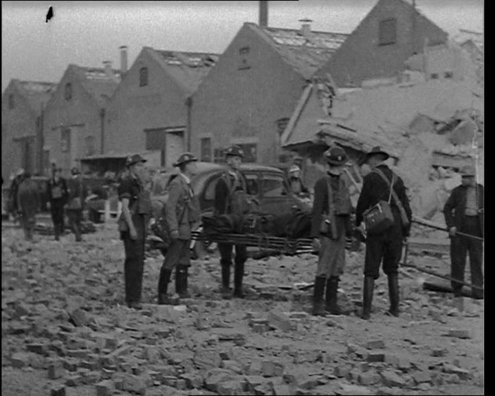
Fire-fighting in Clydebank still continuing (J80.1) e.g. Livingstone Street (M21.2)

Afternoon Scottish Home and Health Dept official arrives to oversee burial of the dead – found around 220 bodies laid out in church hall, school and shed at cemetery. (J80.2)

Monday 17th March
Morning: police photograph bodies of Clydebank dead (J80.4)

Afternoon: bulldozer arrived in Clydebank from Inverrary and roads being cleared (J81.2)

Royal Engineers had begun dynamiting dangerous buildings (J81.2)

17.00 mass burial at Dalnottar (J81.2)

Tuesday 18th March
Craigiehall Street: moans heard from wreckage (“five days after the raid”) (J60.3)

Wednesday 19th March
08.10 Mrs McGeachan rescued from Craigiehall Street, died in hospital same day (J60.3)

Corpses at Nelson Street starting to decompose (J67.3)

11.00 demolition squad arrive at Peel Street, 20-30 people still missing (J65.2)

18.00 (estimate) four bodies recovered from Peel Street “by the evening” (J65.2)

Thursday 20th March
Morning: bodies of Jean Spence and her parents recovered at Peel St (J65.3)

Friday 21st March
Morning: groans from ruins of 31-39 Peel St (J65.4)
13.30 Fred Clarke brought out alive (J65.4)
18.30 Fred Clarke died in hospital (Western) (J65.4)
19.15 John Cormack brought out alive (J65.4)

120 Nelson Street: two severed female feet recovered (J68.1)

Friday 28th March
Last two bodies recovered from Kilmun Street (J76.7)

April
Mr Sutherland of 101 Nelson Street reports wife and children missing; two-day search finds nothing. (J68.2)

8th: incident post at Nelson Street closes. (J68.1)

10th: Nelson Street re-opens to traffic. (J68.1)

May

Middle of month: (estimate, based on “two months later”) Final body found at Logan Street (J69.2)