
I chanced
upon this photo, taken in the Ladywell area of Lewisham on 18 September
1940. In common with most wartime
photographs, other recorded details were excluded in case they helped the
enemy. But where was it?
The
Commonwealth War Graves Commission (CWGC) holds the national register of
civilians killed in the Second World War in the UK, at sea and overseas,
including where they died. From this I
could see that on the 17th September there were several incidents in
Lewisham but the one that seemed the best match was in a street called Ladywell
Park.
No street
of that name now exists, but the 1940 edition of Bartholemews Reference Atlas
of Greater London revealed it was a road off of Lewisham High Street (to the
east) opposite to the junction with Ladywell Road. (Later this was the sight of Ladywell Leisure
centre, now demolished.)

In the
background of the photo, at right angles to Ladywell Park, a building is
visible with a distinctive pediment at the roofline. Looking at Google Maps street view, it can be
matched to the building still standing at 324 to 328 Lewisham High Street.

This is the
sight of the junction with Ladywell Park as it looks today:

From the
book “Red Alert” by Lewis Blake, a history of the blitz in south-east London, a
parachute mine exploded at 11.30pm on Tuesday 17th September. This was a naval mine, about 6 feet long,
dropped from a bomber at about 40 mph after the parachute opened. After touching the ground, it had a timer to
explode after 25 seconds and had been used for the first time in the UK on the
previous night. (For more information
see https://www.iwm.org.uk/collections/item/object/30020471).
This is a painting of a mine falling in another incident:
.jpg)
This
extract from the London County Council sows the damage done to Ladywell Park,
black denoting complete destruction:

Blake says
25 people died in this incident although CWGC only lists 24 names. These include
·
John
Smart, a labourer, and four of his children at number 18
·
Richard
Butler, a timberman, his wife, adult daughter, daughter-in-law and two
grandchildren at number 16. At the same
address, George Johnson, a lorry driver, and two of his children.
·
At
number 7, newly married Charles Lawrence, a compositor (typesetter) and his
wife Kathleen.
·
At
number 1, Mary White and her adult daughter Annie, who usually lived in Kentish
Town with her father but was evidently visiting her mother at the time.
A common
idea is that in the Blitz, Londoners slept in stations on the Underground but
of course this depended on there being a station near you and that y could get
a place. Many people either chanced it
at home, used a shelter in their garden, or used a public shelter in the
street. However, less than a week before
at least 36 people had been killed in a public street shelter less than a mile
from Ladywell Park, at Albion Way. This
might have deterred people from going to a similar shelter overnight.
The death
toll could have been higher. One of the
rescuers, John Donno, a labourer, retrieved four people alive by crawling into
the rubble of the houses. He went back
for a fifth person but a rubble fall knocked him out and he had to be rescued
himself, awaking in hospital. For this,
he was awarded the George Medal, the highest award for civilian bravery. Very little is known about John Donno. Born on 18th October 1884, he
lived at 56 Laleham Road at the time, with his wife, Frances. Looking at the original
photo again, we can perhaps imagine him crawling into the wreckage in the
middle of the night
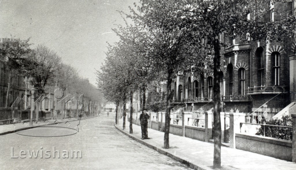
Here are
two views of Ladywell Park, the first probably looking towards Lewisham High
Street and the other looking towards Campshill Road:

The
following aerial view shows the Lewisham URC Church on the corner of Courthill
Road and Lewisham High Street in the bottom left, Lewisham High Street runs
from left to right across the photo in the foreground. Ladywell Park is the tree lined street
running away from the camera on the right hand side and curving towards the
centre of the photo:

This is an
approximation to the same view today:

Finally,
here is a close-up of the houses closest to the High Street:

No comments:
Post a Comment